Fort Worth Star-Telegram · Fort Worth, Texas · 24 May 1948
CP-1948-146
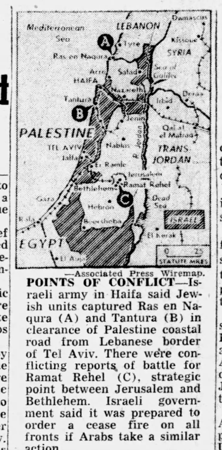
Map of the Palestine frontier
Transcribed from the clipping
—Associated Press Wiremap. POINTS OF CONFLICT—Israeli army in Haifa said Jewish units captured Ras en Naqura (A) and Tantura (B) in clearance of Palestine coastal road from Lebanese border of Tel Aviv. There were conflicting reports of battle for Ramat Rehel (C), strategic point between Jerusalem and Bethlehem.
Israeli government said it was prepared to order a cease fire on all fronts if Arabs take a similar action.
How this transcription was made
Transcribed by optical character recognition and read back against the scan by hand.
Cite this clipping
"Map of the Palestine frontier," Fort Worth Star-Telegram, 24 May 1948. Covering Palestine archive, CP-1948-146. https://coveringpalestine.org/archive/cp-1948-146
More from Fort Worth Star-Telegram
- Strange Customs of Palestine Told by Visitor—Curiosity of Natives One of Aids to Conversion.Fort Worth Star-Telegram · 8 February 1914
- ARABS ‘WILL FIGHT’ U. N. PALESTINE PLANFort Worth Star-Telegram · 1 December 1947
- Arabs Begin ‘War;’ 10 Jews SlainFort Worth Star-Telegram · 1 December 1947
- Israeli Armor Thrusts Deep Inside JordanFort Worth Star-Telegram · 11 October 1956
- 2 dead, 5 hurt from 2 bombs in JerusalemFort Worth Star-Telegram · 14 November 1977
- West Bank propaganda?Fort Worth Star-Telegram · 2 May 1984
- 11 more from this paper in the full text →
More from the 1940s
- Jewish Reprisal Raids On Two Arab Villages Take Toll of 8 LivesThe News Journal · 1 January 1948
- Palestine Blasts Rip Arab OfficesThe New York Times · 5 January 1948
- Jews Blow Up Military Post Of Jaffa ArabsMorning Advocate · 5 January 1948
- Ninety Wounded In Truck Blast At HeadquartersThe Beaumont Enterprise · 5 January 1948
- Jews Dynamite HQ of Arabs’ High CommandDaily News · 5 January 1948
- 15 Arabs Die In Jaffa BlastTerre Haute Tribune · 5 January 1948
- All 339 clippings from the 1940s →
Last updated 17 November 2026
This record is part of Covering Palestine, an archive of American newspaper clippings about Palestinians, 1724 to 2023. Researched and assembled by Maria Robles.
The clipping belongs to the newspaper that printed it, or to the news agency that supplied the copy. It is reproduced here for research, criticism and commentary. A city here is where the newspaper was published, not where the story came from, and on most records it was taken from the masthead.
Something wrong here, or something you know about this clipping? The archive is still being built and corrections are wanted: maria@rozumstudio.com, quoting CP-1948-146.
Everything printed in 1948 · Printed on this day · See it in the archive reel · Full text of every clipping · Dataset